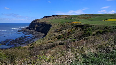
The route starts at sea level (Saltburn) and follows cliff tops while returning to sea level twice (Skinningrove and Staithes). It includes the highest point on the east coast - Boulby Cliff.
I left Val and her Mum in Saltburn to drive back at their leisure to our holiday cottage in Staithes, while I walked the costal route back.
 |
| My route as recorded by ViewRanger |
For reasons of geography, the view 'back' was nearly always more picturesque than looking 'forwards', so consider these images as photos rather than an aid to navigation.
Click on any of these photos for a full screen 'lightbox' view.
 |
| From the end of Saltburn pier to the route ahead |
 |
| Looking along the pier to the cliff railway |
 |
| The route out of Saltburn |
 |
| Looking back at Saltburn |
 |
| Looking back at Saltburn with Redcar, Middlesbrough and Hartlepool in the distance |
 |
| The path squeezes between the cliff edge and the railway line. |
 |
| Art on the Cleveland Way - the Circle or the Charm Bracelet |
 |
| The way ahead |
 |
| Guibal fan house - above the mines beneath our feet. Abandoned around 100 years ago. |
 |
| Cattersty sands with Skinningrove just around the corner. |
 |
| I'm glad I came down this, not up it ! |
 |
| The rail incline into Skinnigrove harbour |
 |
| Looking back at Cattersty Sands |
 |
| Skinningrove harbour |
 |
| The way ahead |
 |
| Out of Skinningrove, up a few steps ! |
 |
| Looking back at Skinningrove |
 |
| The National Trust own a lot around here |
 |
| Hummersea Cliffs |
 |
| Looking back across the gorse |
 |
| We're getting higher ! |
 |
| The alum tips from the old quarries form a baron landscape. |
 |
| If you look hard, you can see some of the old alum mine buildings. Staithes is in the distance. |
 |
| Now at the highest point on the east coast ! Boulby Cliff - 203 meters above sea level. |
 |
| Staithes is getting closer. |
 |
| The route is well signposted along most of it's length |
 |
| The cliffs just north of Staithes. |
 |
| And back to Staithes ! |
 |
| My ViewRanger stats |
No comments:
Post a Comment